Introduction
The geological materials such as volcanic, sedimental, and metamorphic rocks tell us the “memory of the earth”. The Shirataki Geopark tries to use such a memory of the earth for a better future and sustainable development of human society. Let’s read out the story and memory of the earth in Shirataki Geopark.
1. Memories in sand and mud. So-called “accretionary prism”.
The memory of the earth that remained in Shirataki Geopark starts with the sand and mud. When you read that this story starts with sand and mud, you may consider that this is a boring story. However, the sand and mud observed in Shirataki Geopark records the dynamic story of the activity of the earth. Let’s figure out the evidence on this page.

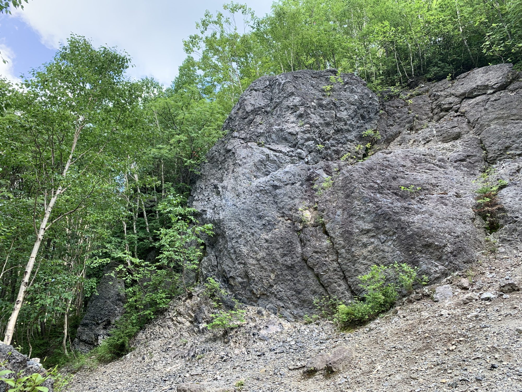
See Fig.1. This figure shows the sand and mud observed in Shirataki Geopark. You can see that the rocks of sand and mud alternately accumulate at Kamishiyubetsu, Shirataki. The point of this location is that the structure of the sand and mud looks complicated, rippled form. Such a complicated structure is the key point to read out the earth’s story.
Please imagine that the sand and mud deposit in calm water. In calm water conditions, the sand and mud accumulate well-stratified like a mille-feuille. However, sand and mud in Shirataki accumulate in rippled form, and such structure reflects that after the accumulation sand and mud deformed by the process on the earth. In fact, this deformation process is driven by the activity on the surface of the earth.

The surface of the earth is considered to be composed of several plates, and these plates are relatively moving. In some places, plates are colliding and the other places plates are spreading. In a colliding case, the sedimented materials on the oceanic plate accrete toward the continental plate and accumulated sediments of mud and sand become deformed by the force due to plate movement (Fig. 2). As seen above the deformed sand and mud is called “accretionary prism” and the evidence of the plate colliding. Hokkaido is composed of the accretionary prism and the sand and mud in Shirataki Geopark tell us the dynamic story of the earth.
2. Formation of the land by the collision of plate
Shirataki Geopark has the other 2 geological evidence of plate collision events. One is the “Shirataki tectonic line” and the other is “Shirataki granite”.

Shirataki tectonic line is a huge geologic fault ranging from Hokkaido to the northern part of Sakhalin (Fig. 3). Such a huge fault is formed by the collision of the Eurasian plate and North American plate. Furthermore, Shirataki granite also records the plate collision that occurred in Hokkaido.

Granite is a plutonic rock formed by the slow cooling in the earth and characterized by white color (Fig.4).

See Fig.5. You can see that the texture of Shirataki granite is fragmented. Such a fragmented texture recorded in Shirataki granite is formed by the dynamics of plate collision.
Plate movement has continued in Hokkaido and the plate collision makes the interior of the earth upward toward the surface and finally formed Hidaka Mountains. For example, we can touch the “peridotite” which is the characteristic rock composed of the mantle of the earth at the Mt. Apoi Geopark, one of the Geopark friends in Hokkaido. The peridotites are considered to be delivered from the mantle of the interior earth and had been lifted up by the collision of the plates. The basement of Hokkaido was formed by the plate collision.
3. Shining stars on the ground. The birth of obsidian.
The most important, characteristic rock of Shirataki Geopark is obsidian. Obsidian is a beautiful volcanic rock composed of an entirely glassy texture. In Hokkaido, we also call the obsidian “Tokachi ishi” as the local name. Shirataki Geopark has the memory of the earth about the volcanic activity originates the obsidian and the memory of human activity who used the obsidian as tools.

In Shirataki Geopark, geological and archeological studies are promoted. A geological survey revealed that 9 obsidian lava flows erupted at ca. 2.2 Ma in Shirataki (Fig. 6).

Shirataki obsidians indicate black color (occasionally oxblood red), and can be divided into two types; one is jet-black luster type and the other is pear-feel type (e.g. Kimura, 2005). This difference is because of the species of minerals in the rock texture, that jet-black luster type is composed of the magnetite and pear-feel type is composed of magnetite and plagioclase (Fig. 7).

The geological survey also revealed the structure of obsidian lava in Shirataki. For example, see Fig.8 showing the Tokachi-Ishizawa outcrop. The interior of obsidian lava is composed of outer obsidian and interior rhyolite, these are identified by the rock texture. Rhyolite is composed of glass and crystalline materials such as spherulite and lithophysae (Fig.8). The thickness of the obsidian layer in Tokachi-Ishizawa lava is over 5 m. Such a different lava structure in obsidian lava is considered to be formed by the vesiculation, outgassing, and cooling during the eruption.
The earth’s memory in Shirataki Geopark also contains the human activity who used the obsidian as tools. These remains show that obsidian from Shirataki is an important resource for humanity in Paleolithic Period. The chemical characteristics are also investigated, and such data sets are utilized to identify the source of obsidian tools. Shirataki Geopark is the frontier of the study of obsidian.